
Our review
 Analysis by Lookingapps
onX Hunt is most useful when a hunting trip depends on understanding the land before you arrive. I see its biggest strength in bringing map reading, property boundaries, and route planning into one place, rather than making you piece together several tools. That focus makes it a practical companion for scouting and navigating, though it is less compelling if you only need a basic map or rarely hunt unfamiliar ground.
Planning around the land, not just the destination
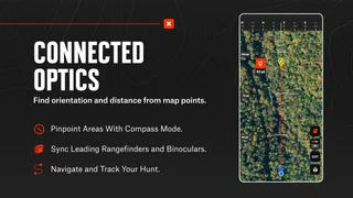
Built by onXmaps as a sports app, onX Hunt puts the questions a hunter asks before heading out at the center of the experience: what does the terrain look like, where do property boundaries fall, and how can I plan a route through the area? Topographic maps, GPS navigation, property lines, and map layers are especially relevant when a promising spot is not as straightforward to reach as it first appears.
I like that this combination encourages planning at two scales. You can think about the broad shape of a hunt—where the terrain changes and which areas deserve a closer look—then use GPS navigation to stay oriented as you move. Property information adds a separate, practical check: a route that looks convenient on a topo map still needs to respect boundaries.
That does not mean an app replaces careful judgment. A map is a planning aid, not permission to cross land, a guarantee that a boundary is easy to identify on the ground, or a substitute for checking current local rules. I would use its layers to prepare, then treat them as information to verify rather than as the final word in a sensitive situation.
Where the map layers earn their place
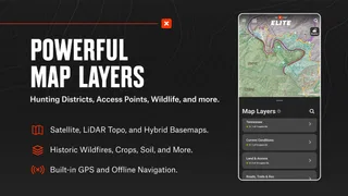
Layers are more valuable when they answer a specific question than when they are simply switched on because they are available. For example, I would first inspect the terrain to identify a route worth considering, then check property lines before committing to it. This order reduces the chance of planning around a path that creates an avoidable boundary problem.
A useful habit is to mark a few alternatives while planning rather than depending on one perfect route. If the terrain looks less workable than expected, or access is awkward, a second option gives you somewhere to reassess. The app’s mix of map layers and GPS navigation makes that kind of preparation more coherent than relying on a general-purpose map alone.
The distinction between a map that looks clear at home and one that is useful outdoors matters. Before a trip, I would inspect the area at more than one zoom level, note recognizable terrain features, and think through where a boundary might affect a route. That preparation is a more dependable use of mapping than waiting until you are moving to decide what the screen means.
More articles

Instagram Makes Everyday Moments Worth Sharing
A rare social app that can be a photo diary, a neighborhood window, and a lively conversation in the same session—though its best moments still require a little restraint.
A practical trip-planning routine
Imagine planning a weekend hunt in a new area. At home, I would use the topo view to understand the shape of the ground, identify a likely approach, and check how property lines relate to that route. I would also consider a backup approach rather than assuming the first line on the screen will work on foot. Once there, GPS navigation can help me keep track of my position relative to the plan.
This is where the app can save mental effort: the route, terrain, and ownership context are connected in the same planning workflow. It does not remove the need to pay attention to landmarks or reassess conditions, but it can make it easier to notice when the route I imagined conflicts with the map information in front of me.
For scouting, I would use it to compare several areas before choosing where to spend time, not to pretend that a map can predict what I will find. Terrain and access help narrow the search; they do not guarantee a successful hunt. That distinction keeps the tool useful without asking it to do more than mapping and navigation can reasonably do.
What it does better than a basic map
A standard navigation app is often designed around roads, addresses, and everyday travel. That is a different job from planning movement across hunting ground. The combination of topo mapping and property lines gives onX Hunt a more relevant starting point for hunters who need to reason about terrain and land ownership together.
Paper maps still have a place: they do not depend on a screen being convenient to use, and some people prefer to see a whole area at a glance. A general offline map may also be enough for someone who only wants broad orientation. I would choose onX Hunt over those simpler options when property boundaries and hunting-specific planning are central, but I would not assume that a specialized app makes basic map-reading skills unnecessary.
Its audience is reflected in its reach: it has more than five million installs, an average rating of 4.5 from around sixty-five thousand ratings, and roughly twenty-two thousand written reviews. Those figures suggest many people find the idea useful, but they do not tell me whether its particular workflow fits an individual hunter. The deciding question is whether you will regularly use its land-focused planning tools.
The main trade-off: preparation and paid extras
The app is free to install, but it includes in-app purchases ranging from $9.99 to $99.99 per item. That makes it sensible to try the free experience and judge your own routine before spending. If you only need an occasional look at a familiar place, paid options may not be worth prioritizing; if map-based preparation is part of most trips, the added cost may feel more justified.
I would also avoid assuming that a phone-based navigation workflow is effortless in every situation. Looking at a screen while moving can distract from the ground, and a route that seems obvious on a display still needs real-world attention. The most responsible approach is to plan before setting out, check the map when it is safe to do so, and keep awareness of surroundings ahead of convenience.
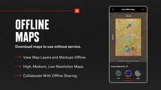
Offline use deserves particular care in any hunting-map workflow. The app’s name may lead people to expect a simple answer, but I would not head into a remote area without checking the specific map access available in the app and preparing the relevant area in advance. Do that while you have a reliable connection, and do not make the phone your only navigation plan. A backup and basic map-reading confidence matter more as conditions become less predictable.
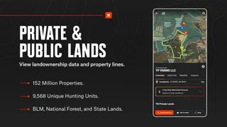
Property lines are another area where sensible expectations matter. The layer can help you plan around ownership boundaries, but a screen cannot resolve every on-the-ground ambiguity or replace permission. If access is uncertain, I would pause and verify it rather than treating a displayed line as an invitation to proceed. This caution is not a flaw unique to this app; it is part of using digital land information responsibly.
Who will get the most from it
I would recommend onX Hunt to hunters who explore unfamiliar ground, routinely compare potential areas, or want topo context and property information together while planning. It is especially useful for someone who thinks through an approach before leaving and wants to carry that planning into navigation, rather than switching between a general map and separate boundary references.
It is a weaker fit for a person who hunts the same easy-to-navigate location, has little use for property layers, or wants a map mainly for ordinary driving. It may also frustrate anyone expecting a map to settle questions that require local confirmation. In those cases, a simpler map—or a paper backup paired with careful local research—could be the more sensible choice.
The content rating is Everyone, and the app first appeared on November 8, 2013. It supports Android 8.0 and later, which is useful to check before installing on an older device. These details help establish whether it is available for your setup, but the more important fit question remains practical: will you use its mapping tools enough to make them part of your preparation?
My verdict after weighing the trade-offs
My overall view is that onX Hunt has a clear purpose and a useful advantage over everyday navigation apps for hunting-specific planning: it brings terrain, property context, and GPS guidance into one workflow. Its strongest value is not a promise of a better hunt, but the chance to make more informed decisions about where to go and how to approach the ground.
I would start by using it to plan a familiar area, compare a couple of routes, and see whether the map layers genuinely change how I prepare. If they do, it may earn a regular place in your kit. If you only need occasional orientation, the free app can still be worth trying, but I would be cautious about paying for extras until your own use makes the benefit clear.
For hunters who plan around terrain and land boundaries, it is a focused and worthwhile tool; for everyone else, its specialized strengths may be more than they need.
Pros
- Detailed land ownership maps help identify property boundaries.
- Offline maps remain available in areas without cell service.
- Custom waypoints make it easy to mark hunting locations.
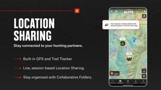
- GPS tracking helps you retrace routes in the field.
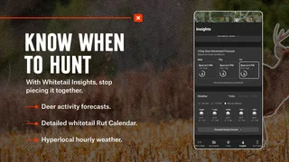
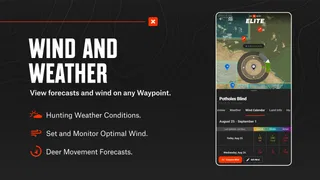
- Weather and wind details support trip planning.
Cons
- Many advanced map layers require a paid subscription.
- Map downloads can use substantial storage space.
- Some property boundary data may be outdated or inaccurate.
- Frequent GPS use can drain your phone battery.
- The range of map layers may feel overwhelming to new users.


